|
|
|||||||||||||||||
| Point ID: 3006 | Downloads | Plots | Site Data | Code: 05OE002 |
|
|
|||||||||||||||||
| Download | |
|---|---|
| Site Descriptor Information | Site Time Series Data |
| Link to all available data | |
| View: | Time Series | All |
| Units: | m3/s |
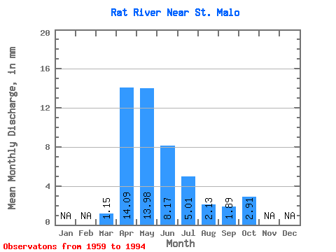
| Statistic | Jan | Feb | Mar | Apr | May | Jun | Jul | Aug | Sep | Oct | Nov | Dec | Annual |
|---|---|---|---|---|---|---|---|---|---|---|---|---|---|
| Mean | 1.15 | 14.09 | 13.98 | 8.17 | 5.00 | 2.13 | 1.89 | 2.91 | |||||
| Standard Deviation | 1.55 | 12.55 | 11.69 | 6.42 | 4.97 | 3.58 | 2.93 | 3.88 | |||||
| Min | 0.00 | 1.12 | 1.10 | 0.09 | 0.01 | 0.00 | 0.00 | 0.00 | |||||
| Max | 6.87 | 53.12 | 44.22 | 25.16 | 19.54 | 13.27 | 12.54 | 16.75 | |||||
| Coefficient of Variation | 1.35 | 0.89 | 0.84 | 0.79 | 0.99 | 1.68 | 1.55 | 1.33 |
 Return to R-Arctic Net Home Page