|
|
|||||||||||||||||
| Point ID: 2977 | Downloads | Plots | Site Data | Code: 05OB025 |
|
|
|||||||||||||||||
| Download | |
|---|---|
| Site Descriptor Information | Site Time Series Data |
| Link to all available data | |
| View: | Time Series | All |
| Units: | m3/s |
| Statistic | Jan | Feb | Mar | Apr | May | Jun | Jul | Aug | Sep | Oct | Nov | Dec | Annual |
|---|---|---|---|---|---|---|---|---|---|---|---|---|---|
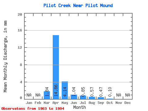
| Mean | 1.84 | 14.86 | 4.14 | 1.04 | 0.86 | 0.57 | 0.47 | 0.11 | |||||
| Standard Deviation | 3.26 | 19.80 | 8.74 | 2.03 | 2.10 | 2.09 | 1.30 | 0.31 | |||||
| Min | 0.00 | 0.03 | 0.00 | 0.00 | 0.00 | 0.00 | 0.00 | 0.00 | |||||
| Max | 11.65 | 78.27 | 45.56 | 6.88 | 9.15 | 10.80 | 5.55 | 1.30 | |||||
| Coefficient of Variation | 1.77 | 1.33 | 2.11 | 1.95 | 2.45 | 3.65 | 2.74 | 2.81 |
 Return to R-Arctic Net Home Page