|
|
|||||||||||||||||
| Point ID: 2973 | Downloads | Plots | Site Data | Code: 05OB016 |
|
|
|||||||||||||||||
| Download | |
|---|---|
| Site Descriptor Information | Site Time Series Data |
| Link to all available data | |
| View: | Time Series | All |
| Units: | m3/s |
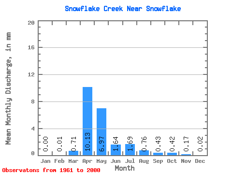
| Statistic | Jan | Feb | Mar | Apr | May | Jun | Jul | Aug | Sep | Oct | Nov | Dec | Annual |
|---|---|---|---|---|---|---|---|---|---|---|---|---|---|
| Mean | 0.00 | 0.01 | 0.71 | 10.13 | 6.97 | 1.64 | 1.69 | 0.76 | 0.43 | 0.42 | 0.17 | 0.02 | 23.52 |
| Standard Deviation | 0.02 | 0.06 | 1.25 | 13.47 | 13.62 | 2.33 | 6.43 | 2.07 | 1.29 | 1.23 | 0.56 | 0.10 | 34.24 |
| Min | 0.00 | 0.00 | 0.00 | 0.02 | 0.01 | 0.00 | 0.00 | 0.00 | 0.00 | 0.00 | 0.00 | 0.00 | 0.12 |
| Max | 0.10 | 0.35 | 5.76 | 49.94 | 73.16 | 9.20 | 40.95 | 10.73 | 7.48 | 5.46 | 2.99 | 0.59 | 175.73 |
| Coefficient of Variation | 5.51 | 4.89 | 1.77 | 1.33 | 1.95 | 1.42 | 3.80 | 2.74 | 3.02 | 2.91 | 3.24 | 4.48 | 1.46 |
 Return to R-Arctic Net Home Page