|
|
|||||||||||||||||
| Point ID: 2972 | Downloads | Plots | Site Data | Code: 05OB013 |
|
|
|||||||||||||||||
| Download | |
|---|---|
| Site Descriptor Information | Site Time Series Data |
| Link to all available data | |
| View: | Time Series | All |
| Units: | m3/s |
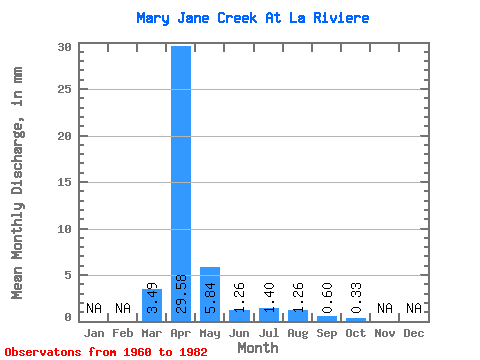
| Statistic | Jan | Feb | Mar | Apr | May | Jun | Jul | Aug | Sep | Oct | Nov | Dec | Annual |
|---|---|---|---|---|---|---|---|---|---|---|---|---|---|
| Mean | 3.48 | 29.57 | 5.85 | 1.27 | 1.40 | 1.27 | 0.60 | 0.33 | |||||
| Standard Deviation | 8.11 | 28.83 | 9.63 | 1.38 | 2.38 | 4.26 | 1.34 | 0.33 | |||||
| Min | 0.00 | 0.00 | 0.37 | 0.17 | 0.06 | 0.00 | 0.00 | 0.00 | |||||
| Max | 31.05 | 89.41 | 37.45 | 6.44 | 8.02 | 18.32 | 5.84 | 1.32 | |||||
| Coefficient of Variation | 2.33 | 0.97 | 1.65 | 1.09 | 1.70 | 3.37 | 2.23 | 1.01 |
 Return to R-Arctic Net Home Page