|
|
|||||||||||||||||
| Point ID: 2970 | Downloads | Plots | Site Data | Code: 05OB008 |
|
|
|||||||||||||||||
| Download | |
|---|---|
| Site Descriptor Information | Site Time Series Data |
| Link to all available data | |
| View: | Time Series | All |
| Units: | m3/s |
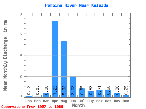
| Statistic | Jan | Feb | Mar | Apr | May | Jun | Jul | Aug | Sep | Oct | Nov | Dec | Annual |
|---|---|---|---|---|---|---|---|---|---|---|---|---|---|
| Mean | 0.12 | 0.07 | 0.38 | 7.22 | 5.32 | 2.03 | 0.85 | 0.58 | 0.71 | 0.68 | 0.38 | 0.25 | 18.45 |
| Standard Deviation | 0.18 | 0.13 | 0.56 | 9.79 | 5.37 | 1.62 | 0.82 | 0.48 | 1.14 | 1.15 | 0.50 | 0.35 | 17.43 |
| Min | 0.00 | 0.00 | 0.00 | 1.17 | 0.60 | 0.20 | 0.03 | 0.01 | 0.00 | 0.00 | 0.00 | 0.00 | 3.67 |
| Max | 0.58 | 0.42 | 1.87 | 34.54 | 17.80 | 4.87 | 2.82 | 1.43 | 4.11 | 4.28 | 1.73 | 1.15 | 64.28 |
| Coefficient of Variation | 1.58 | 1.91 | 1.48 | 1.36 | 1.01 | 0.80 | 0.97 | 0.83 | 1.61 | 1.71 | 1.32 | 1.42 | 0.94 |
 Return to R-Arctic Net Home Page