|
|
|||||||||||||||||
| Point ID: 2964 | Downloads | Plots | Site Data | Code: 05OA014 |
|
|
|||||||||||||||||
| Download | |
|---|---|
| Site Descriptor Information | Site Time Series Data |
| Link to all available data | |
| View: | Time Series | All |
| Units: | m3/s |
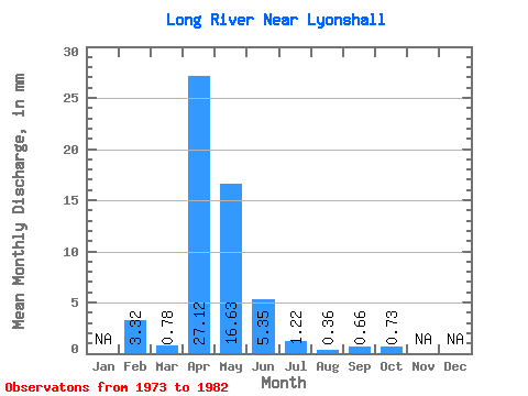
| Statistic | Jan | Feb | Mar | Apr | May | Jun | Jul | Aug | Sep | Oct | Nov | Dec | Annual |
|---|---|---|---|---|---|---|---|---|---|---|---|---|---|
| Mean | 3.35 | 0.77 | 27.11 | 16.63 | 5.35 | 1.22 | 0.35 | 0.65 | 0.73 | ||||
| Standard Deviation | 1.21 | 28.60 | 22.45 | 6.34 | 1.25 | 0.50 | 0.98 | 0.79 | |||||
| Min | 3.35 | 0.00 | 0.46 | 0.05 | 0.03 | 0.00 | 0.00 | 0.00 | 0.05 | ||||
| Max | 3.35 | 3.19 | 79.56 | 70.85 | 21.49 | 4.49 | 1.64 | 3.18 | 2.05 | ||||
| Coefficient of Variation | 1.56 | 1.05 | 1.35 | 1.19 | 1.03 | 1.44 | 1.52 | 1.08 |
 Return to R-Arctic Net Home Page