|
|
|||||||||||||||||
| Point ID: 2961 | Downloads | Plots | Site Data | Code: 05OA010 |
|
|
|||||||||||||||||
| Download | |
|---|---|
| Site Descriptor Information | Site Time Series Data |
| Link to all available data | |
| View: | Time Series | All |
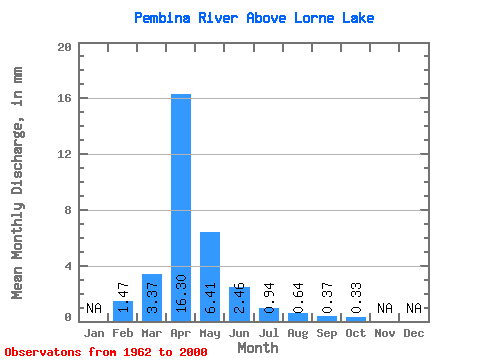
| Units: | m3/s |
| Statistic | Jan | Feb | Mar | Apr | May | Jun | Jul | Aug | Sep | Oct | Nov | Dec | Annual |
|---|---|---|---|---|---|---|---|---|---|---|---|---|---|
| Mean | 1.48 | 3.37 | 16.30 | 6.41 | 2.46 | 0.94 | 0.64 | 0.37 | 0.33 | ||||
| Standard Deviation | 5.62 | 18.60 | 10.60 | 3.23 | 1.09 | 1.12 | 1.09 | 0.49 | |||||
| Min | 1.48 | 0.00 | 0.10 | 0.09 | 0.01 | 0.00 | 0.00 | 0.00 | 0.00 | ||||
| Max | 1.48 | 21.17 | 61.85 | 58.54 | 12.09 | 3.94 | 5.22 | 6.75 | 2.26 | ||||
| Coefficient of Variation | 1.67 | 1.14 | 1.66 | 1.31 | 1.16 | 1.74 | 2.95 | 1.49 |
 Return to R-Arctic Net Home Page