|
|
|||||||||||||||||
| Point ID: 2956 | Downloads | Plots | Site Data | Code: 05OA005 |
|
|
|||||||||||||||||
| Download | |
|---|---|
| Site Descriptor Information | Site Time Series Data |
| Link to all available data | |
| View: | Time Series | All |
| Units: | m3/s |
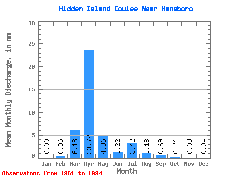
| Statistic | Jan | Feb | Mar | Apr | May | Jun | Jul | Aug | Sep | Oct | Nov | Dec | Annual |
|---|---|---|---|---|---|---|---|---|---|---|---|---|---|
| Mean | 0.00 | 0.35 | 6.19 | 23.70 | 4.95 | 1.23 | 3.43 | 1.19 | 0.69 | 0.23 | 0.06 | 0.04 | 42.18 |
| Standard Deviation | 0.00 | 2.00 | 15.53 | 33.06 | 10.35 | 2.53 | 11.69 | 3.88 | 3.15 | 0.90 | 0.22 | 0.20 | 42.64 |
| Min | 0.00 | 0.00 | 0.00 | 0.00 | 0.00 | 0.00 | 0.00 | 0.00 | 0.00 | 0.00 | 0.00 | 0.00 | 0.04 |
| Max | 0.00 | 11.50 | 86.13 | 126.00 | 48.77 | 10.09 | 63.72 | 19.04 | 18.04 | 5.15 | 1.14 | 1.14 | 182.23 |
| Coefficient of Variation | 5.75 | 2.51 | 1.40 | 2.09 | 2.06 | 3.41 | 3.27 | 4.54 | 3.99 | 3.53 | 5.45 | 1.01 |
 Return to R-Arctic Net Home Page