|
|
|||||||||||||||||
| Point ID: 2941 | Downloads | Plots | Site Data | Code: 05NG007 |
|
|
|||||||||||||||||
| Download | |
|---|---|
| Site Descriptor Information | Site Time Series Data |
| Link to all available data | |
| View: | Time Series | All |
| Units: | m3/s |
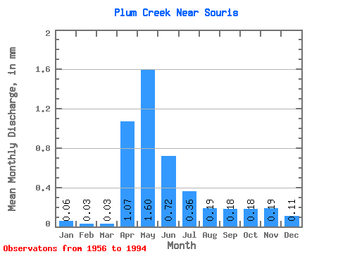
| Statistic | Jan | Feb | Mar | Apr | May | Jun | Jul | Aug | Sep | Oct | Nov | Dec | Annual |
|---|---|---|---|---|---|---|---|---|---|---|---|---|---|
| Mean | 0.06 | 0.04 | 0.03 | 1.07 | 1.60 | 0.71 | 0.36 | 0.19 | 0.18 | 0.18 | 0.19 | 0.11 | 5.96 |
| Standard Deviation | 0.26 | 0.15 | 0.07 | 4.26 | 3.14 | 1.39 | 0.73 | 0.42 | 0.41 | 0.48 | 0.44 | 0.33 | 11.34 |
| Min | 0.00 | 0.00 | 0.00 | 0.00 | 0.00 | 0.00 | 0.00 | 0.00 | 0.00 | 0.00 | 0.00 | 0.00 | 0.02 |
| Max | 1.29 | 0.75 | 0.37 | 26.69 | 14.34 | 5.93 | 3.06 | 2.02 | 1.82 | 2.47 | 2.07 | 1.62 | 52.56 |
| Coefficient of Variation | 4.11 | 4.29 | 2.33 | 3.97 | 1.97 | 1.94 | 2.04 | 2.23 | 2.31 | 2.58 | 2.29 | 3.07 | 1.90 |
 Return to R-Arctic Net Home Page