|
|
|||||||||||||||||
| Point ID: 2940 | Downloads | Plots | Site Data | Code: 05NG004 |
|
|
|||||||||||||||||
| Download | |
|---|---|
| Site Descriptor Information | Site Time Series Data |
| Link to all available data | |
| View: | Time Series | All |
| Units: | m3/s |
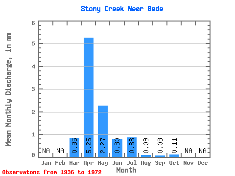
| Statistic | Jan | Feb | Mar | Apr | May | Jun | Jul | Aug | Sep | Oct | Nov | Dec | Annual |
|---|---|---|---|---|---|---|---|---|---|---|---|---|---|
| Mean | 0.85 | 5.25 | 2.27 | 0.80 | 0.88 | 0.09 | 0.08 | 0.11 | |||||
| Standard Deviation | 1.79 | 4.98 | 4.56 | 1.88 | 1.92 | 0.17 | 0.23 | 0.31 | |||||
| Min | 0.00 | 0.04 | 0.00 | 0.00 | 0.00 | 0.00 | 0.00 | 0.00 | |||||
| Max | 5.19 | 12.92 | 14.28 | 5.43 | 5.48 | 0.44 | 0.65 | 0.87 | |||||
| Coefficient of Variation | 2.11 | 0.95 | 2.01 | 2.35 | 2.19 | 1.94 | 2.83 | 2.83 |
 Return to R-Arctic Net Home Page