|
|
|||||||||||||||||
| Point ID: 2922 | Downloads | Plots | Site Data | Code: 05MJ007 |
|
|
|||||||||||||||||
| Download | |
|---|---|
| Site Descriptor Information | Site Time Series Data |
| Link to all available data | |
| View: | Time Series | All |
| Units: | m3/s |
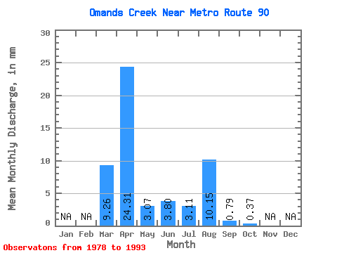
| Statistic | Jan | Feb | Mar | Apr | May | Jun | Jul | Aug | Sep | Oct | Nov | Dec | Annual |
|---|---|---|---|---|---|---|---|---|---|---|---|---|---|
| Mean | 9.26 | 24.30 | 3.07 | 3.81 | 3.10 | 10.17 | 0.78 | 0.38 | |||||
| Standard Deviation | 9.15 | 18.09 | 5.63 | 7.56 | 7.39 | 24.57 | 1.11 | 0.38 | |||||
| Min | 0.52 | 2.51 | 0.04 | 0.11 | 0.15 | 0.00 | 0.04 | 0.00 | |||||
| Max | 22.00 | 52.34 | 16.00 | 25.67 | 25.30 | 82.23 | 3.84 | 1.00 | |||||
| Coefficient of Variation | 0.99 | 0.74 | 1.83 | 1.98 | 2.38 | 2.42 | 1.43 | 1.00 |
 Return to R-Arctic Net Home Page