|
|
|||||||||||||||||
| Point ID: 292 | Downloads | Plots | Site Data | Code: 05BJ001 |
|
|
|||||||||||||||||
| Download | |
|---|---|
| Site Descriptor Information | Site Time Series Data |
| Link to all available data | |
| View: | Time Series | All |
| Units: | m3/s |
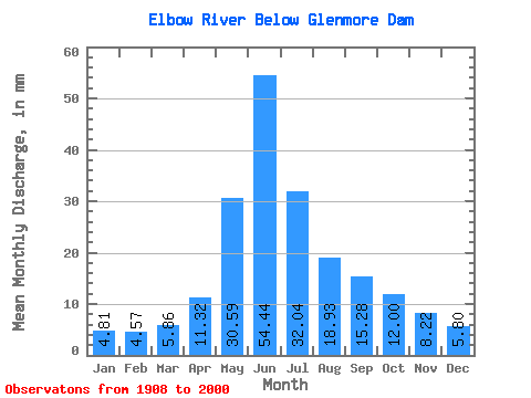
| Statistic | Jan | Feb | Mar | Apr | May | Jun | Jul | Aug | Sep | Oct | Nov | Dec | Annual |
|---|---|---|---|---|---|---|---|---|---|---|---|---|---|
| Mean | 4.81 | 4.61 | 5.86 | 11.32 | 30.59 | 54.44 | 32.03 | 18.93 | 15.28 | 11.99 | 8.22 | 5.80 | 202.17 |
| Standard Deviation | 2.41 | 2.25 | 3.53 | 8.22 | 18.55 | 34.41 | 22.21 | 13.63 | 14.31 | 8.07 | 4.02 | 2.71 | 98.99 |
| Min | 0.93 | 0.84 | 0.70 | 1.07 | 2.81 | 5.33 | 2.87 | 2.63 | 1.47 | 2.24 | 1.97 | 1.24 | 50.91 |
| Max | 13.59 | 9.94 | 23.30 | 50.15 | 94.93 | 193.24 | 119.09 | 64.01 | 79.45 | 38.32 | 22.76 | 12.00 | 539.38 |
| Coefficient of Variation | 0.50 | 0.49 | 0.60 | 0.73 | 0.61 | 0.63 | 0.69 | 0.72 | 0.94 | 0.67 | 0.49 | 0.47 | 0.49 |
 Return to R-Arctic Net Home Page