|
|
|||||||||||||||||
| Point ID: 2916 | Downloads | Plots | Site Data | Other Close Sites | Code: 05MH013 |
|
|
|||||||||||||||||
| Download | |
|---|---|
| Site Descriptor Information | Site Time Series Data |
| Link to all available data | |
| View: | Time Series | All |
| Units: | m3/s |
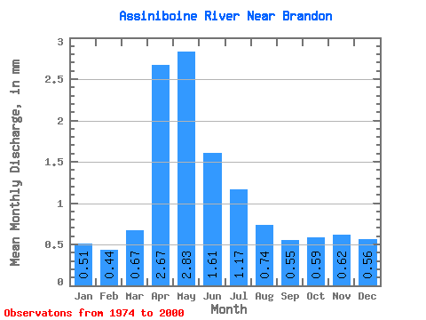
| Statistic | Jan | Feb | Mar | Apr | May | Jun | Jul | Aug | Sep | Oct | Nov | Dec | Annual |
|---|---|---|---|---|---|---|---|---|---|---|---|---|---|
| Mean | 0.51 | 0.44 | 0.67 | 2.67 | 2.83 | 1.61 | 1.17 | 0.74 | 0.55 | 0.59 | 0.62 | 0.56 | 12.94 |
| Standard Deviation | 0.19 | 0.17 | 0.31 | 2.30 | 3.29 | 1.55 | 0.94 | 0.59 | 0.45 | 0.37 | 0.26 | 0.20 | 8.73 |
| Min | 0.15 | 0.15 | 0.23 | 0.41 | 0.19 | 0.19 | 0.13 | 0.12 | 0.14 | 0.11 | 0.17 | 0.16 | 2.77 |
| Max | 0.95 | 0.85 | 1.38 | 10.20 | 14.85 | 5.39 | 3.02 | 1.80 | 1.93 | 1.87 | 1.47 | 1.05 | 34.80 |
| Coefficient of Variation | 0.38 | 0.38 | 0.46 | 0.86 | 1.16 | 0.96 | 0.80 | 0.80 | 0.82 | 0.63 | 0.41 | 0.37 | 0.68 |
| Other Close Sites | ||||||
|---|---|---|---|---|---|---|
| PointID | Latitude | Longitude | Drainage Area | Source | Name | |
| 2908 | "ASSINIBOINE RIVER AT BRANDON" | 49.85 | 754247 | Hydat | ||
 Return to R-Arctic Net Home Page