|
|
|||||||||||||||||
| Point ID: 2913 | Downloads | Plots | Site Data | Code: 05MH007 |
|
|
|||||||||||||||||
| Download | |
|---|---|
| Site Descriptor Information | Site Time Series Data |
| Link to all available data | |
| View: | Time Series | All |
| Units: | m3/s |
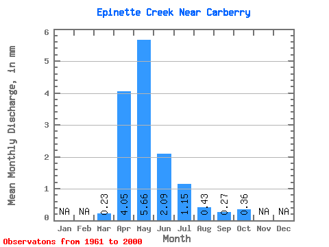
| Statistic | Jan | Feb | Mar | Apr | May | Jun | Jul | Aug | Sep | Oct | Nov | Dec | Annual |
|---|---|---|---|---|---|---|---|---|---|---|---|---|---|
| Mean | 0.23 | 4.05 | 5.65 | 2.09 | 1.15 | 0.43 | 0.27 | 0.36 | |||||
| Standard Deviation | 0.43 | 4.85 | 6.64 | 2.20 | 1.73 | 0.95 | 0.50 | 0.68 | |||||
| Min | 0.00 | 0.01 | 0.00 | 0.00 | 0.00 | 0.00 | 0.00 | 0.00 | |||||
| Max | 2.64 | 20.58 | 26.11 | 7.65 | 8.64 | 5.69 | 2.34 | 3.56 | |||||
| Coefficient of Variation | 1.85 | 1.20 | 1.18 | 1.05 | 1.50 | 2.23 | 1.86 | 1.90 |
 Return to R-Arctic Net Home Page