|
|
|||||||||||||||||
| Point ID: 2912 | Downloads | Plots | Site Data | Code: 05MH006 |
|
|
|||||||||||||||||
| Download | |
|---|---|
| Site Descriptor Information | Site Time Series Data |
| Link to all available data | |
| View: | Time Series | All |
| Units: | m3/s |
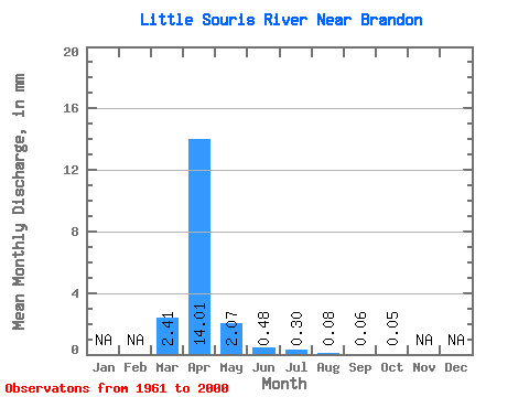
| Statistic | Jan | Feb | Mar | Apr | May | Jun | Jul | Aug | Sep | Oct | Nov | Dec | Annual |
|---|---|---|---|---|---|---|---|---|---|---|---|---|---|
| Mean | 2.41 | 14.01 | 2.07 | 0.48 | 0.30 | 0.08 | 0.06 | 0.06 | |||||
| Standard Deviation | 4.33 | 15.99 | 5.19 | 0.82 | 0.71 | 0.24 | 0.23 | 0.25 | |||||
| Min | 0.00 | 0.00 | 0.00 | 0.00 | 0.00 | 0.00 | 0.00 | 0.00 | |||||
| Max | 18.70 | 68.59 | 31.08 | 3.65 | 3.53 | 1.05 | 1.01 | 1.46 | |||||
| Coefficient of Variation | 1.80 | 1.14 | 2.51 | 1.70 | 2.38 | 3.23 | 3.54 | 4.61 |
 Return to R-Arctic Net Home Page