|
|
|||||||||||||||||
| Point ID: 291 | Downloads | Plots | Site Data | Code: 05BH904 |
|
|
|||||||||||||||||
| Download | |
|---|---|
| Site Descriptor Information | Site Time Series Data |
| Link to all available data | |
| View: | Time Series | All |
| Units: | m3/s |
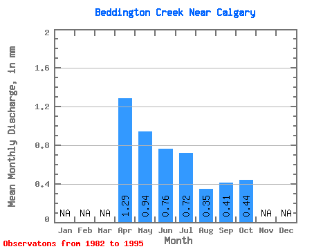
| Statistic | Jan | Feb | Mar | Apr | May | Jun | Jul | Aug | Sep | Oct | Nov | Dec | Annual |
|---|---|---|---|---|---|---|---|---|---|---|---|---|---|
| Mean | 1.29 | 0.94 | 0.76 | 0.71 | 0.35 | 0.41 | 0.45 | ||||||
| Standard Deviation | 1.23 | 0.70 | 0.56 | 0.62 | 0.21 | 0.34 | 0.44 | ||||||
| Min | 0.39 | 0.34 | 0.14 | 0.14 | 0.12 | 0.01 | 0.07 | ||||||
| Max | 3.39 | 2.57 | 2.19 | 1.86 | 0.87 | 1.21 | 1.73 | ||||||
| Coefficient of Variation | 0.95 | 0.74 | 0.74 | 0.88 | 0.61 | 0.83 | 0.98 |
 Return to R-Arctic Net Home Page