|
|
|||||||||||||||||
| Point ID: 2907 | Downloads | Plots | Site Data | Code: 05MG012 |
|
|
|||||||||||||||||
| Download | |
|---|---|
| Site Descriptor Information | Site Time Series Data |
| Link to all available data | |
| View: | Time Series | All |
| Units: | m3/s |
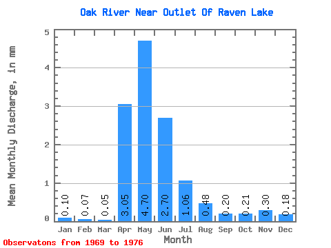
| Statistic | Jan | Feb | Mar | Apr | May | Jun | Jul | Aug | Sep | Oct | Nov | Dec | Annual |
|---|---|---|---|---|---|---|---|---|---|---|---|---|---|
| Mean | 0.10 | 0.07 | 0.05 | 3.05 | 4.70 | 2.70 | 1.06 | 0.48 | 0.20 | 0.21 | 0.30 | 0.18 | 16.24 |
| Standard Deviation | 0.22 | 0.16 | 0.13 | 6.92 | 5.17 | 2.17 | 1.39 | 0.77 | 0.26 | 0.41 | 0.66 | 0.41 | 16.05 |
| Min | 0.00 | 0.00 | 0.00 | 0.08 | 0.01 | 0.00 | 0.00 | 0.00 | 0.00 | 0.00 | 0.00 | 0.00 | 0.10 |
| Max | 0.50 | 0.35 | 0.38 | 20.01 | 12.94 | 5.32 | 4.25 | 2.27 | 0.63 | 1.22 | 1.49 | 0.92 | 41.29 |
| Coefficient of Variation | 2.24 | 2.24 | 2.78 | 2.27 | 1.10 | 0.81 | 1.30 | 1.60 | 1.27 | 1.93 | 2.17 | 2.24 | 0.99 |
 Return to R-Arctic Net Home Page