|
|
|||||||||||||||||
| Point ID: 290 | Downloads | Plots | Site Data | Code: 05BH901 |
|
|
|||||||||||||||||
| Download | |
|---|---|
| Site Descriptor Information | Site Time Series Data |
| Link to all available data | |
| View: | Time Series | All |
| Units: | m3/s |
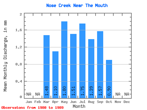
| Statistic | Jan | Feb | Mar | Apr | May | Jun | Jul | Aug | Sep | Oct | Nov | Dec | Annual |
|---|---|---|---|---|---|---|---|---|---|---|---|---|---|
| Mean | 1.48 | 1.10 | 1.79 | 1.51 | 1.75 | 1.39 | 1.57 | 0.90 | |||||
| Standard Deviation | 0.69 | 1.37 | 0.38 | 1.29 | 1.42 | 1.72 | 0.66 | ||||||
| Min | 1.48 | 0.46 | 0.64 | 0.76 | 0.41 | 0.38 | 0.60 | 0.48 | |||||
| Max | 1.48 | 1.94 | 3.77 | 1.89 | 4.13 | 4.59 | 5.68 | 2.46 | |||||
| Coefficient of Variation | 0.62 | 0.77 | 0.25 | 0.74 | 1.02 | 1.09 | 0.73 |
 Return to R-Arctic Net Home Page