|
|
|||||||||||||||||
| Point ID: 2882 | Downloads | Plots | Site Data | Code: 05ME005 |
|
|
|||||||||||||||||
| Download | |
|---|---|
| Site Descriptor Information | Site Time Series Data |
| Link to all available data | |
| View: | Time Series | All |
| Units: | m3/s |
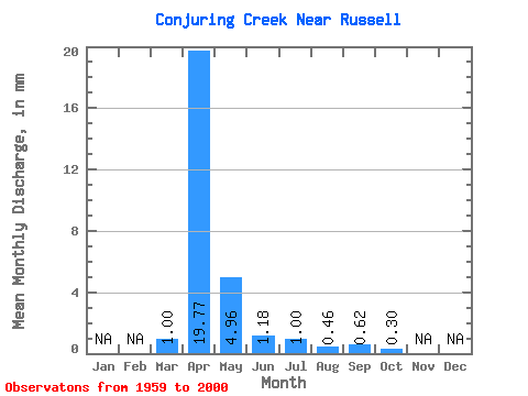
| Statistic | Jan | Feb | Mar | Apr | May | Jun | Jul | Aug | Sep | Oct | Nov | Dec | Annual |
|---|---|---|---|---|---|---|---|---|---|---|---|---|---|
| Mean | 1.01 | 19.76 | 4.96 | 1.16 | 0.99 | 0.46 | 0.61 | 0.31 | |||||
| Standard Deviation | 1.99 | 17.16 | 6.55 | 1.96 | 2.14 | 1.03 | 1.48 | 0.83 | |||||
| Min | 0.00 | 0.03 | 0.00 | 0.00 | 0.00 | 0.00 | 0.00 | 0.00 | |||||
| Max | 7.60 | 79.74 | 25.57 | 7.68 | 10.06 | 4.65 | 6.30 | 4.86 | |||||
| Coefficient of Variation | 1.97 | 0.87 | 1.32 | 1.69 | 2.16 | 2.23 | 2.43 | 2.69 |
 Return to R-Arctic Net Home Page