|
|
|||||||||||||||||
| Point ID: 2877 | Downloads | Plots | Site Data | Code: 05MD005 |
|
|
|||||||||||||||||
| Download | |
|---|---|
| Site Descriptor Information | Site Time Series Data |
| Link to all available data | |
| View: | Time Series | All |
| Units: | m3/s |
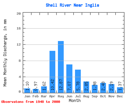
| Statistic | Jan | Feb | Mar | Apr | May | Jun | Jul | Aug | Sep | Oct | Nov | Dec | Annual |
|---|---|---|---|---|---|---|---|---|---|---|---|---|---|
| Mean | 1.10 | 0.97 | 1.62 | 10.42 | 12.87 | 7.07 | 5.78 | 2.85 | 1.98 | 2.48 | 2.19 | 1.37 | 46.32 |
| Standard Deviation | 0.48 | 0.42 | 1.14 | 5.62 | 10.41 | 6.74 | 5.51 | 2.78 | 1.69 | 1.68 | 1.43 | 0.60 | 21.21 |
| Min | 0.00 | 0.00 | 0.00 | 1.92 | 1.85 | 1.02 | 0.43 | 0.19 | 0.16 | 0.43 | 0.72 | 0.02 | 10.43 |
| Max | 2.34 | 2.11 | 6.21 | 25.66 | 43.52 | 39.14 | 26.11 | 14.33 | 7.17 | 9.01 | 8.45 | 2.93 | 105.45 |
| Coefficient of Variation | 0.43 | 0.43 | 0.70 | 0.54 | 0.81 | 0.95 | 0.95 | 0.98 | 0.85 | 0.68 | 0.65 | 0.44 | 0.46 |
 Return to R-Arctic Net Home Page