|
|
|||||||||||||||||
| Point ID: 2873 | Downloads | Plots | Site Data | Code: 05LN002 |
|
|
|||||||||||||||||
| Download | |
|---|---|
| Site Descriptor Information | Site Time Series Data |
| Link to all available data | |
| View: | Time Series | All |
| Units: | m3/s |
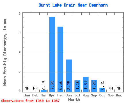
| Statistic | Jan | Feb | Mar | Apr | May | Jun | Jul | Aug | Sep | Oct | Nov | Dec | Annual |
|---|---|---|---|---|---|---|---|---|---|---|---|---|---|
| Mean | 0.19 | 7.53 | 6.56 | 3.25 | 1.16 | 1.51 | 1.22 | 0.42 | |||||
| Standard Deviation | 0.48 | 12.84 | 10.72 | 7.60 | 3.45 | 4.47 | 3.90 | 1.48 | |||||
| Min | 0.00 | 0.02 | 0.04 | 0.00 | 0.00 | 0.00 | 0.00 | 0.00 | |||||
| Max | 2.29 | 65.96 | 38.01 | 37.33 | 12.59 | 18.36 | 15.91 | 6.13 | |||||
| Coefficient of Variation | 2.55 | 1.71 | 1.63 | 2.34 | 2.97 | 2.96 | 3.19 | 3.49 |
 Return to R-Arctic Net Home Page