|
|
|||||||||||||||||
| Point ID: 2867 | Downloads | Plots | Site Data | Code: 05LL024 |
|
|
|||||||||||||||||
| Download | |
|---|---|
| Site Descriptor Information | Site Time Series Data |
| Link to all available data | |
| View: | Time Series | All |
| Units: | m3/s |
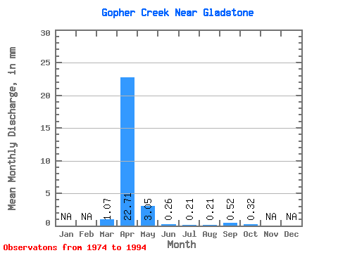
| Statistic | Jan | Feb | Mar | Apr | May | Jun | Jul | Aug | Sep | Oct | Nov | Dec | Annual |
|---|---|---|---|---|---|---|---|---|---|---|---|---|---|
| Mean | 1.09 | 22.69 | 3.07 | 0.26 | 0.20 | 0.20 | 0.54 | 0.32 | |||||
| Standard Deviation | 2.05 | 50.48 | 7.23 | 0.41 | 0.34 | 0.34 | 0.93 | 0.56 | |||||
| Min | 0.00 | 0.00 | 0.00 | 0.00 | 0.00 | 0.00 | 0.00 | 0.00 | |||||
| Max | 7.18 | 198.55 | 25.23 | 1.71 | 0.59 | 0.59 | 1.61 | 0.96 | |||||
| Coefficient of Variation | 1.88 | 2.23 | 2.35 | 1.59 | 1.73 | 1.73 | 1.73 | 1.73 |
 Return to R-Arctic Net Home Page