|
|
|||||||||||||||||
| Point ID: 2859 | Downloads | Plots | Site Data | Code: 05LL014 |
|
|
|||||||||||||||||
| Download | |
|---|---|
| Site Descriptor Information | Site Time Series Data |
| Link to all available data | |
| View: | Time Series | All |
| Units: | m3/s |
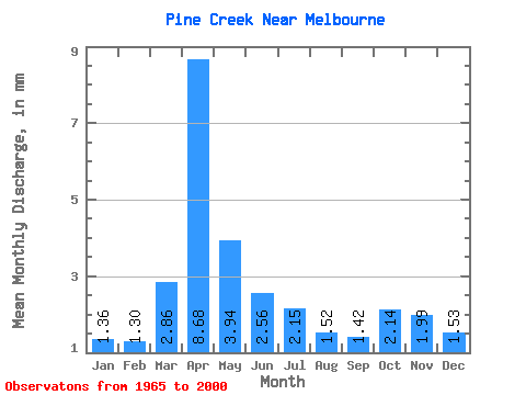
| Statistic | Jan | Feb | Mar | Apr | May | Jun | Jul | Aug | Sep | Oct | Nov | Dec | Annual |
|---|---|---|---|---|---|---|---|---|---|---|---|---|---|
| Mean | 1.36 | 1.31 | 2.86 | 8.68 | 3.94 | 2.56 | 2.15 | 1.51 | 1.43 | 2.14 | 1.99 | 1.53 | 30.88 |
| Standard Deviation | 0.31 | 0.33 | 1.56 | 5.87 | 2.08 | 1.10 | 1.23 | 0.89 | 0.69 | 0.68 | 0.56 | 0.42 | 8.80 |
| Min | 0.89 | 0.81 | 0.99 | 1.36 | 1.25 | 1.11 | 0.74 | 0.55 | 0.53 | 0.68 | 0.86 | 0.89 | 15.57 |
| Max | 1.94 | 2.17 | 6.50 | 21.91 | 9.08 | 6.06 | 5.60 | 4.42 | 3.06 | 3.45 | 3.33 | 2.47 | 51.95 |
| Coefficient of Variation | 0.23 | 0.25 | 0.55 | 0.68 | 0.53 | 0.43 | 0.57 | 0.59 | 0.48 | 0.32 | 0.28 | 0.27 | 0.28 |
 Return to R-Arctic Net Home Page