|
|
|||||||||||||||||
| Point ID: 2854 | Downloads | Plots | Site Data | Code: 05LL007 |
|
|
|||||||||||||||||
| Download | |
|---|---|
| Site Descriptor Information | Site Time Series Data |
| Link to all available data | |
| View: | Time Series | All |
| Units: | m3/s |
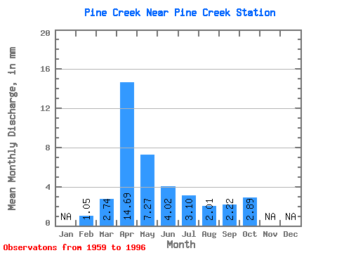
| Statistic | Jan | Feb | Mar | Apr | May | Jun | Jul | Aug | Sep | Oct | Nov | Dec | Annual |
|---|---|---|---|---|---|---|---|---|---|---|---|---|---|
| Mean | 1.06 | 2.74 | 14.70 | 7.27 | 4.03 | 3.10 | 2.01 | 2.21 | 2.89 | ||||
| Standard Deviation | 1.94 | 9.31 | 4.02 | 1.71 | 1.92 | 1.32 | 1.53 | 1.07 | |||||
| Min | 1.06 | 0.05 | 2.71 | 2.38 | 1.14 | 1.00 | 0.53 | 0.62 | 1.86 | ||||
| Max | 1.06 | 8.81 | 34.94 | 19.61 | 9.71 | 9.24 | 5.69 | 7.06 | 6.20 | ||||
| Coefficient of Variation | 0.71 | 0.63 | 0.55 | 0.42 | 0.62 | 0.66 | 0.69 | 0.37 |
 Return to R-Arctic Net Home Page