|
|
|||||||||||||||||
| Point ID: 2843 | Downloads | Plots | Site Data | Code: 05LJ040 |
|
|
|||||||||||||||||
| Download | |
|---|---|
| Site Descriptor Information | Site Time Series Data |
| Link to all available data | |
| View: | Time Series | All |
| Units: | m3/s |
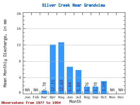
| Statistic | Jan | Feb | Mar | Apr | May | Jun | Jul | Aug | Sep | Oct | Nov | Dec | Annual |
|---|---|---|---|---|---|---|---|---|---|---|---|---|---|
| Mean | 0.78 | 12.11 | 12.62 | 6.63 | 5.82 | 1.77 | 1.78 | 3.10 | |||||
| Standard Deviation | 1.08 | 8.63 | 16.08 | 9.18 | 8.56 | 4.16 | 3.83 | 2.92 | |||||
| Min | 0.00 | 2.02 | 0.51 | 0.04 | 0.00 | 0.00 | 0.00 | 0.00 | |||||
| Max | 3.40 | 30.27 | 53.56 | 34.24 | 28.15 | 16.87 | 14.27 | 9.64 | |||||
| Coefficient of Variation | 1.38 | 0.71 | 1.27 | 1.38 | 1.47 | 2.35 | 2.15 | 0.94 |
 Return to R-Arctic Net Home Page