|
|
|||||||||||||||||
| Point ID: 2832 | Downloads | Plots | Site Data | Code: 05LJ022 |
|
|
|||||||||||||||||
| Download | |
|---|---|
| Site Descriptor Information | Site Time Series Data |
| Link to all available data | |
| View: | Time Series | All |
| Units: | m3/s |
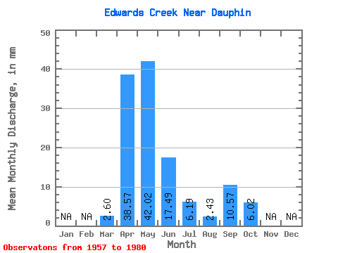
| Statistic | Jan | Feb | Mar | Apr | May | Jun | Jul | Aug | Sep | Oct | Nov | Dec | Annual |
|---|---|---|---|---|---|---|---|---|---|---|---|---|---|
| Mean | 2.61 | 38.57 | 42.03 | 17.48 | 6.19 | 2.42 | 10.58 | 6.01 | |||||
| Standard Deviation | 2.90 | 27.86 | 45.83 | 19.28 | 6.95 | 2.62 | 27.08 | 6.44 | |||||
| Min | 0.00 | 7.78 | 2.96 | 0.47 | 0.57 | 0.00 | 0.00 | 0.11 | |||||
| Max | 12.16 | 99.30 | 167.09 | 81.05 | 26.78 | 11.03 | 131.24 | 25.65 | |||||
| Coefficient of Variation | 1.11 | 0.72 | 1.09 | 1.10 | 1.12 | 1.08 | 2.56 | 1.07 |
 Return to R-Arctic Net Home Page