|
|
|||||||||||||||||
| Point ID: 2829 | Downloads | Plots | Site Data | Code: 05LJ019 |
|
|
|||||||||||||||||
| Download | |
|---|---|
| Site Descriptor Information | Site Time Series Data |
| Link to all available data | |
| View: | Time Series | All |
| Units: | m3/s |
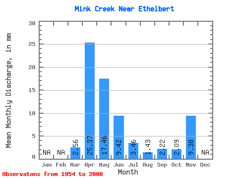
| Statistic | Jan | Feb | Mar | Apr | May | Jun | Jul | Aug | Sep | Oct | Nov | Dec | Annual |
|---|---|---|---|---|---|---|---|---|---|---|---|---|---|
| Mean | 2.55 | 25.37 | 17.45 | 9.41 | 3.46 | 1.43 | 2.22 | 2.08 | 9.38 | ||||
| Standard Deviation | 4.04 | 21.34 | 17.87 | 16.29 | 5.83 | 2.49 | 4.10 | 1.86 | |||||
| Min | 0.00 | 1.44 | 1.04 | 0.46 | 0.12 | 0.00 | 0.02 | 0.51 | 9.38 | ||||
| Max | 18.89 | 93.59 | 66.23 | 86.47 | 32.50 | 12.18 | 23.55 | 11.28 | 9.38 | ||||
| Coefficient of Variation | 1.59 | 0.84 | 1.02 | 1.73 | 1.69 | 1.74 | 1.85 | 0.89 |
 Return to R-Arctic Net Home Page