|
|
|||||||||||||||||
| Point ID: 2809 | Downloads | Plots | Site Data | Code: 05LG004 |
|
|
|||||||||||||||||
| Download | |
|---|---|
| Site Descriptor Information | Site Time Series Data |
| Link to all available data | |
| View: | Time Series | All |
| Units: | m3/s |
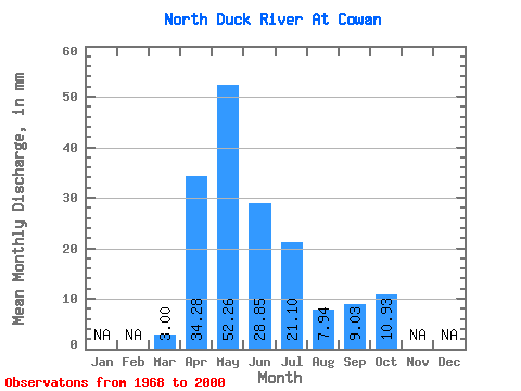
| Statistic | Jan | Feb | Mar | Apr | May | Jun | Jul | Aug | Sep | Oct | Nov | Dec | Annual |
|---|---|---|---|---|---|---|---|---|---|---|---|---|---|
| Mean | 3.00 | 34.28 | 52.25 | 28.85 | 21.10 | 7.94 | 9.03 | 10.93 | |||||
| Standard Deviation | 2.23 | 23.36 | 41.97 | 27.26 | 27.89 | 9.34 | 12.05 | 10.16 | |||||
| Min | 0.10 | 7.96 | 4.82 | 1.27 | 0.73 | 0.62 | 0.71 | 1.99 | |||||
| Max | 8.57 | 96.12 | 168.13 | 105.89 | 148.91 | 42.03 | 51.61 | 46.84 | |||||
| Coefficient of Variation | 0.74 | 0.68 | 0.80 | 0.94 | 1.32 | 1.18 | 1.33 | 0.93 |
 Return to R-Arctic Net Home Page