|
|
|||||||||||||||||
| Point ID: 2798 | Downloads | Plots | Site Data | Code: 05LE003 |
|
|
|||||||||||||||||
| Download | |
|---|---|
| Site Descriptor Information | Site Time Series Data |
| Link to all available data | |
| View: | Time Series | All |
| Units: | m3/s |
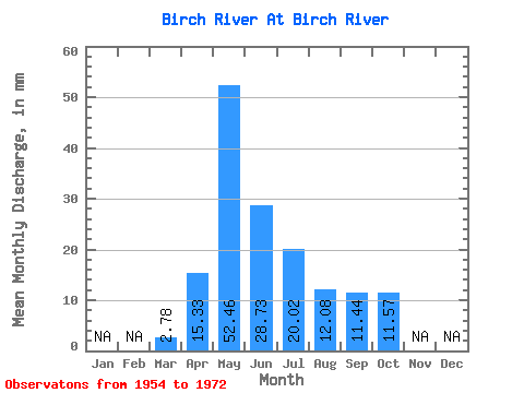
| Statistic | Jan | Feb | Mar | Apr | May | Jun | Jul | Aug | Sep | Oct | Nov | Dec | Annual |
|---|---|---|---|---|---|---|---|---|---|---|---|---|---|
| Mean | 2.79 | 15.33 | 52.46 | 28.72 | 20.00 | 12.09 | 11.43 | 11.56 | |||||
| Standard Deviation | 1.99 | 12.14 | 36.15 | 22.80 | 15.70 | 13.31 | 11.67 | 12.08 | |||||
| Min | 0.00 | 0.85 | 6.25 | 3.52 | 2.64 | 2.56 | 1.96 | 3.19 | |||||
| Max | 5.21 | 41.55 | 131.45 | 83.70 | 55.40 | 54.99 | 39.77 | 54.99 | |||||
| Coefficient of Variation | 0.71 | 0.79 | 0.69 | 0.79 | 0.79 | 1.10 | 1.02 | 1.04 |
 Return to R-Arctic Net Home Page