|
|
|||||||||||||||||
| Point ID: 2795 | Downloads | Plots | Site Data | Code: 05LD001 |
|
|
|||||||||||||||||
| Download | |
|---|---|
| Site Descriptor Information | Site Time Series Data |
| Link to all available data | |
| View: | Time Series | All |
| Units: | m3/s |
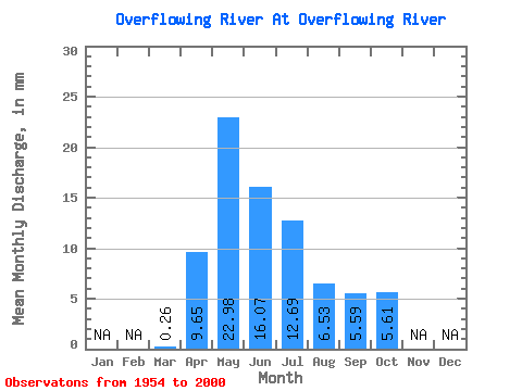
| Statistic | Jan | Feb | Mar | Apr | May | Jun | Jul | Aug | Sep | Oct | Nov | Dec | Annual |
|---|---|---|---|---|---|---|---|---|---|---|---|---|---|
| Mean | 0.26 | 9.65 | 22.97 | 16.07 | 12.69 | 6.53 | 5.59 | 5.61 | |||||
| Standard Deviation | 0.46 | 6.16 | 16.39 | 13.46 | 12.29 | 7.57 | 6.95 | 4.58 | |||||
| Min | 0.00 | 0.68 | 2.00 | 0.32 | 0.09 | 0.02 | 0.01 | 0.01 | |||||
| Max | 2.91 | 26.77 | 59.16 | 55.79 | 53.48 | 45.17 | 29.71 | 18.55 | |||||
| Coefficient of Variation | 1.78 | 0.64 | 0.71 | 0.84 | 0.97 | 1.16 | 1.24 | 0.81 |
 Return to R-Arctic Net Home Page