|
|
|||||||||||||||||
| Point ID: 2793 | Downloads | Plots | Site Data | Code: 05LC004 |
|
|
|||||||||||||||||
| Download | |
|---|---|
| Site Descriptor Information | Site Time Series Data |
| Link to all available data | |
| View: | Time Series | All |
| Units: | m3/s |
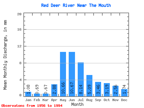
| Statistic | Jan | Feb | Mar | Apr | May | Jun | Jul | Aug | Sep | Oct | Nov | Dec | Annual |
|---|---|---|---|---|---|---|---|---|---|---|---|---|---|
| Mean | 1.08 | 0.70 | 0.67 | 2.88 | 10.66 | 10.67 | 8.14 | 5.09 | 3.46 | 3.19 | 2.56 | 1.74 | 51.16 |
| Standard Deviation | 0.82 | 0.56 | 0.54 | 1.91 | 7.89 | 8.37 | 5.53 | 3.56 | 2.41 | 2.06 | 1.95 | 1.37 | 26.16 |
| Min | 0.02 | 0.00 | 0.00 | 0.44 | 1.28 | 1.11 | 1.08 | 0.37 | 0.14 | 0.11 | 0.04 | 0.08 | 10.53 |
| Max | 3.32 | 2.05 | 1.88 | 8.24 | 31.40 | 33.78 | 18.65 | 14.55 | 12.76 | 8.75 | 8.08 | 5.87 | 98.81 |
| Coefficient of Variation | 0.77 | 0.80 | 0.81 | 0.66 | 0.74 | 0.79 | 0.68 | 0.70 | 0.70 | 0.64 | 0.76 | 0.79 | 0.51 |
 Return to R-Arctic Net Home Page