|
|
|||||||||||||||||
| Point ID: 2785 | Downloads | Plots | Site Data | Code: 04AA004 |
|
|
|||||||||||||||||
| Download | |
|---|---|
| Site Descriptor Information | Site Time Series Data |
| Link to all available data | |
| View: | Time Series | All |
| Units: | m3/s |
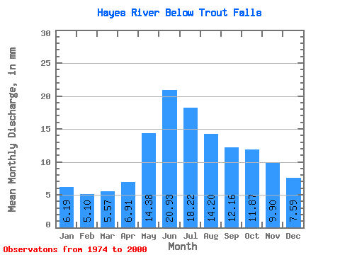
| Statistic | Jan | Feb | Mar | Apr | May | Jun | Jul | Aug | Sep | Oct | Nov | Dec | Annual |
|---|---|---|---|---|---|---|---|---|---|---|---|---|---|
| Mean | 6.19 | 5.14 | 5.57 | 6.91 | 14.38 | 20.93 | 18.21 | 14.20 | 12.16 | 11.87 | 9.90 | 7.59 | 135.11 |
| Standard Deviation | 3.09 | 2.33 | 2.39 | 2.63 | 5.26 | 11.49 | 10.00 | 6.61 | 5.07 | 5.43 | 5.04 | 3.79 | 48.26 |
| Min | 1.64 | 1.38 | 1.69 | 2.99 | 5.65 | 4.85 | 5.13 | 2.56 | 3.78 | 4.34 | 2.88 | 2.02 | 63.53 |
| Max | 14.05 | 10.94 | 12.47 | 14.86 | 30.02 | 44.56 | 37.30 | 25.64 | 22.87 | 29.72 | 25.81 | 18.12 | 221.56 |
| Coefficient of Variation | 0.50 | 0.45 | 0.43 | 0.38 | 0.37 | 0.55 | 0.55 | 0.47 | 0.42 | 0.46 | 0.51 | 0.50 | 0.36 |
 Return to R-Arctic Net Home Page