|
|
|||||||||||||||||
| Point ID: 2774 | Downloads | Plots | Site Data | Code: 10CB001 |
|
|
|||||||||||||||||
| Download | |
|---|---|
| Site Descriptor Information | Site Time Series Data |
| Link to all available data | |
| View: | Time Series | All |
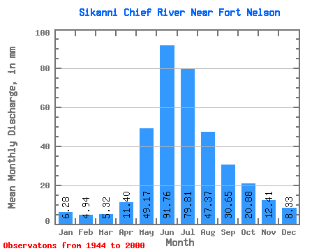
| Units: | m3/s |
| Statistic | Jan | Feb | Mar | Apr | May | Jun | Jul | Aug | Sep | Oct | Nov | Dec | Annual |
|---|---|---|---|---|---|---|---|---|---|---|---|---|---|
| Mean | 6.28 | 4.98 | 5.32 | 11.40 | 49.17 | 91.76 | 79.80 | 47.36 | 30.65 | 20.88 | 12.41 | 8.33 | 377.79 |
| Standard Deviation | 1.44 | 1.15 | 1.56 | 11.26 | 22.37 | 31.99 | 29.51 | 26.77 | 13.85 | 7.52 | 6.06 | 2.12 | 90.63 |
| Min | 3.46 | 2.85 | 0.59 | 0.84 | 16.37 | 45.12 | 32.36 | 16.74 | 11.26 | 8.03 | 5.47 | 4.64 | 226.44 |
| Max | 8.80 | 7.15 | 10.96 | 76.32 | 119.89 | 183.60 | 174.81 | 126.46 | 75.84 | 41.91 | 45.72 | 13.64 | 596.38 |
| Coefficient of Variation | 0.23 | 0.23 | 0.29 | 0.99 | 0.46 | 0.35 | 0.37 | 0.56 | 0.45 | 0.36 | 0.49 | 0.25 | 0.24 |
 Return to R-Arctic Net Home Page