|
|
|||||||||||||||||
| Point ID: 2773 | Downloads | Plots | Site Data | Code: 10CA001 |
|
|
|||||||||||||||||
| Download | |
|---|---|
| Site Descriptor Information | Site Time Series Data |
| Link to all available data | |
| View: | Time Series | All |
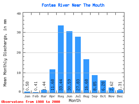
| Units: | m3/s |
| Statistic | Jan | Feb | Mar | Apr | May | Jun | Jul | Aug | Sep | Oct | Nov | Dec | Annual |
|---|---|---|---|---|---|---|---|---|---|---|---|---|---|
| Mean | 0.58 | 0.42 | 1.44 | 11.68 | 33.44 | 30.59 | 27.82 | 16.68 | 8.85 | 6.28 | 2.62 | 1.31 | 140.96 |
| Standard Deviation | 0.28 | 0.18 | 2.41 | 7.56 | 21.41 | 17.26 | 22.12 | 20.97 | 6.10 | 4.57 | 1.35 | 0.92 | 31.00 |
| Min | 0.20 | 0.10 | 0.32 | 4.20 | 3.51 | 8.69 | 5.50 | 2.49 | 1.08 | 1.30 | 0.87 | 0.48 | 90.08 |
| Max | 1.06 | 0.64 | 7.67 | 25.82 | 71.29 | 63.75 | 63.33 | 70.57 | 17.86 | 16.14 | 4.90 | 3.18 | 191.14 |
| Coefficient of Variation | 0.47 | 0.42 | 1.67 | 0.65 | 0.64 | 0.56 | 0.80 | 1.26 | 0.69 | 0.73 | 0.52 | 0.70 | 0.22 |
 Return to R-Arctic Net Home Page