|
|
|||||||||||||||||
| Point ID: 2772 | Downloads | Plots | Site Data | Code: 10BE013 |
|
|
|||||||||||||||||
| Download | |
|---|---|
| Site Descriptor Information | Site Time Series Data |
| Link to all available data | |
| View: | Time Series | All |
| Units: | m3/s |
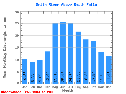
| Statistic | Jan | Feb | Mar | Apr | May | Jun | Jul | Aug | Sep | Oct | Nov | Dec | Annual |
|---|---|---|---|---|---|---|---|---|---|---|---|---|---|
| Mean | 10.25 | 9.06 | 9.85 | 13.44 | 25.12 | 25.48 | 24.90 | 21.55 | 18.34 | 17.84 | 13.02 | 11.49 | 202.87 |
| Standard Deviation | 2.50 | 2.07 | 1.93 | 2.53 | 6.22 | 9.48 | 11.39 | 7.39 | 4.32 | 3.48 | 2.42 | 2.72 | 44.44 |
| Min | 5.43 | 5.57 | 7.52 | 7.42 | 13.96 | 14.14 | 13.89 | 14.03 | 12.41 | 12.82 | 9.22 | 4.66 | 146.41 |
| Max | 16.90 | 12.98 | 13.39 | 17.60 | 38.74 | 49.14 | 61.01 | 39.60 | 26.89 | 24.49 | 17.12 | 17.11 | 316.37 |
| Coefficient of Variation | 0.24 | 0.23 | 0.20 | 0.19 | 0.25 | 0.37 | 0.46 | 0.34 | 0.23 | 0.20 | 0.19 | 0.24 | 0.22 |
 Return to R-Arctic Net Home Page