|
|
|||||||||||||||||
| Point ID: 2752 | Downloads | Plots | Site Data | Code: 10AC003 |
|
|
|||||||||||||||||
| Download | |
|---|---|
| Site Descriptor Information | Site Time Series Data |
| Link to all available data | |
| View: | Time Series | All |
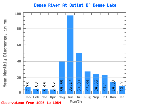
| Units: | m3/s |
| Statistic | Jan | Feb | Mar | Apr | May | Jun | Jul | Aug | Sep | Oct | Nov | Dec | Annual |
|---|---|---|---|---|---|---|---|---|---|---|---|---|---|
| Mean | 7.98 | 6.08 | 5.49 | 5.05 | 39.94 | 96.17 | 50.29 | 27.38 | 24.65 | 23.41 | 14.99 | 10.01 | 321.49 |
| Standard Deviation | 1.73 | 1.20 | 1.06 | 0.78 | 18.20 | 38.60 | 25.65 | 12.28 | 11.73 | 8.70 | 5.20 | 2.47 | 74.22 |
| Min | 4.78 | 3.90 | 3.56 | 3.97 | 9.53 | 32.23 | 15.52 | 9.57 | 8.37 | 8.77 | 8.07 | 5.87 | 145.74 |
| Max | 11.05 | 7.99 | 7.45 | 6.96 | 96.55 | 177.35 | 152.22 | 61.84 | 52.86 | 42.11 | 30.01 | 15.28 | 524.91 |
| Coefficient of Variation | 0.22 | 0.20 | 0.19 | 0.15 | 0.46 | 0.40 | 0.51 | 0.45 | 0.48 | 0.37 | 0.35 | 0.25 | 0.23 |
 Return to R-Arctic Net Home Page