|
|
|||||||||||||||||
| Point ID: 2750 | Downloads | Plots | Site Data | Code: 09AE004 |
|
|
|||||||||||||||||
| Download | |
|---|---|
| Site Descriptor Information | Site Time Series Data |
| Link to all available data | |
| View: | Time Series | All |
| Units: | m3/s |
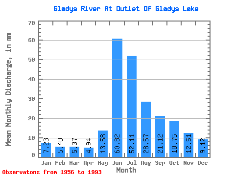
| Statistic | Jan | Feb | Mar | Apr | May | Jun | Jul | Aug | Sep | Oct | Nov | Dec | Annual |
|---|---|---|---|---|---|---|---|---|---|---|---|---|---|
| Mean | 7.23 | 5.53 | 5.37 | 4.94 | 13.58 | 60.82 | 52.10 | 28.57 | 21.12 | 18.75 | 12.51 | 9.12 | 244.57 |
| Standard Deviation | 1.36 | 1.10 | 1.47 | 1.18 | 6.54 | 17.54 | 14.01 | 6.93 | 7.99 | 6.95 | 4.13 | 2.08 | 33.07 |
| Min | 5.19 | 4.13 | 3.62 | 3.41 | 4.98 | 36.51 | 17.81 | 9.81 | 7.29 | 6.00 | 5.31 | 6.03 | 166.14 |
| Max | 10.96 | 8.67 | 12.23 | 10.23 | 30.71 | 107.62 | 89.87 | 49.63 | 50.89 | 34.07 | 23.75 | 13.81 | 304.28 |
| Coefficient of Variation | 0.19 | 0.20 | 0.27 | 0.24 | 0.48 | 0.29 | 0.27 | 0.24 | 0.38 | 0.37 | 0.33 | 0.23 | 0.14 |
 Return to R-Arctic Net Home Page