|
|
|||||||||||||||||
| Point ID: 2747 | Downloads | Plots | Site Data | Code: 09AA014 |
|
|
|||||||||||||||||
| Download | |
|---|---|
| Site Descriptor Information | Site Time Series Data |
| Link to all available data | |
| View: | Time Series | All |
| Units: | m3/s |
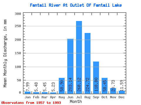
| Statistic | Jan | Feb | Mar | Apr | May | Jun | Jul | Aug | Sep | Oct | Nov | Dec | Annual |
|---|---|---|---|---|---|---|---|---|---|---|---|---|---|
| Mean | 7.98 | 5.53 | 5.45 | 5.24 | 58.90 | 203.14 | 268.08 | 224.69 | 118.80 | 58.45 | 20.73 | 11.59 | 978.20 |
| Standard Deviation | 2.35 | 1.36 | 2.78 | 2.01 | 33.44 | 46.63 | 42.84 | 39.03 | 42.70 | 22.93 | 7.08 | 4.07 | 137.95 |
| Min | 4.00 | 3.15 | 2.63 | 2.42 | 16.77 | 125.08 | 167.70 | 134.46 | 52.06 | 18.90 | 8.64 | 5.83 | 708.78 |
| Max | 13.71 | 8.30 | 18.82 | 10.19 | 155.38 | 294.99 | 340.26 | 312.25 | 212.20 | 125.50 | 45.19 | 26.63 | 1238.12 |
| Coefficient of Variation | 0.29 | 0.25 | 0.51 | 0.38 | 0.57 | 0.23 | 0.16 | 0.17 | 0.36 | 0.39 | 0.34 | 0.35 | 0.14 |
 Return to R-Arctic Net Home Page