|
|
|||||||||||||||||
| Point ID: 274 | Downloads | Plots | Site Data | Code: 05BG002 |
|
|
|||||||||||||||||
| Download | |
|---|---|
| Site Descriptor Information | Site Time Series Data |
| Link to all available data | |
| View: | Time Series | All |
| Units: | m3/s |
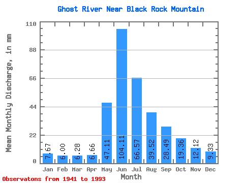
| Statistic | Jan | Feb | Mar | Apr | May | Jun | Jul | Aug | Sep | Oct | Nov | Dec | Annual |
|---|---|---|---|---|---|---|---|---|---|---|---|---|---|
| Mean | 7.67 | 6.04 | 6.29 | 6.66 | 47.10 | 104.11 | 66.56 | 39.51 | 28.48 | 19.36 | 12.12 | 9.33 | 396.72 |
| Standard Deviation | 0.89 | 0.61 | 1.10 | 1.28 | 23.33 | 41.25 | 31.06 | 18.12 | 14.50 | 5.94 | 2.75 | 1.69 | 80.67 |
| Min | 6.11 | 5.32 | 4.85 | 4.09 | 16.37 | 35.87 | 20.18 | 16.37 | 11.61 | 10.23 | 7.99 | 6.37 | 307.87 |
| Max | 8.91 | 6.89 | 9.13 | 10.85 | 125.27 | 206.38 | 140.88 | 98.36 | 84.64 | 39.09 | 19.29 | 12.18 | 527.22 |
| Coefficient of Variation | 0.12 | 0.10 | 0.17 | 0.19 | 0.49 | 0.40 | 0.47 | 0.46 | 0.51 | 0.31 | 0.23 | 0.18 | 0.20 |
 Return to R-Arctic Net Home Page