|
|
|||||||||||||||||
| Point ID: 269 | Downloads | Plots | Site Data | Code: 05BF020 |
|
|
|||||||||||||||||
| Download | |
|---|---|
| Site Descriptor Information | Site Time Series Data |
| Link to all available data | |
| View: | Time Series | All |
| Units: | m3/s |
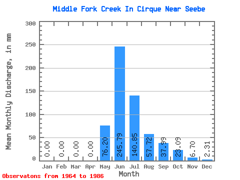
| Statistic | Jan | Feb | Mar | Apr | May | Jun | Jul | Aug | Sep | Oct | Nov | Dec | Annual |
|---|---|---|---|---|---|---|---|---|---|---|---|---|---|
| Mean | 0.99 | 0.30 | 0.00 | 0.00 | 76.60 | 244.68 | 140.61 | 58.16 | 38.96 | 22.43 | 5.75 | 2.64 | 583.82 |
| Standard Deviation | 1.23 | 0.80 | 0.00 | 0.00 | 41.83 | 62.08 | 64.28 | 33.97 | 33.93 | 15.62 | 3.12 | 2.08 | 86.20 |
| Min | 0.00 | 0.00 | 0.00 | 0.00 | 6.93 | 118.43 | 34.63 | 18.47 | 6.70 | 6.93 | 2.23 | 0.00 | 489.72 |
| Max | 2.31 | 2.10 | 0.00 | 0.00 | 140.83 | 366.45 | 274.73 | 129.28 | 151.94 | 62.33 | 11.17 | 6.93 | 668.84 |
| Coefficient of Variation | 1.25 | 2.65 | 0.55 | 0.25 | 0.46 | 0.58 | 0.87 | 0.70 | 0.54 | 0.79 | 0.15 |
 Return to R-Arctic Net Home Page