|
|
|||||||||||||||||
| Point ID: 268 | Downloads | Plots | Site Data | Code: 05BF019 |
|
|
|||||||||||||||||
| Download | |
|---|---|
| Site Descriptor Information | Site Time Series Data |
| Link to all available data | |
| View: | Time Series | All |
| Units: | m3/s |
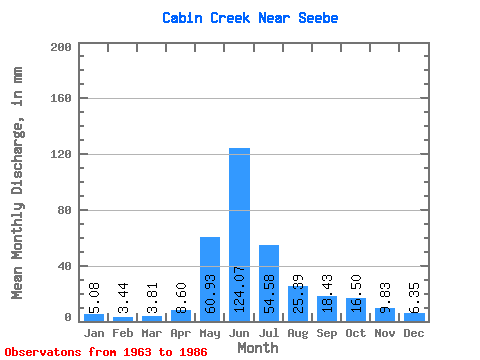
| Statistic | Jan | Feb | Mar | Apr | May | Jun | Jul | Aug | Sep | Oct | Nov | Dec | Annual |
|---|---|---|---|---|---|---|---|---|---|---|---|---|---|
| Mean | 5.08 | 3.80 | 3.81 | 8.01 | 61.27 | 123.61 | 54.95 | 25.54 | 18.02 | 16.34 | 9.78 | 6.56 | 342.18 |
| Standard Deviation | 1.66 | 1.11 | 1.14 | 4.57 | 26.79 | 52.26 | 27.90 | 10.69 | 10.31 | 11.48 | 5.08 | 2.53 | 80.13 |
| Min | 2.54 | 1.16 | 1.27 | 3.69 | 34.27 | 38.08 | 20.31 | 13.96 | 8.60 | 6.35 | 3.69 | 2.54 | 214.39 |
| Max | 8.88 | 5.78 | 6.35 | 22.11 | 124.38 | 238.32 | 130.73 | 55.84 | 55.28 | 55.84 | 22.11 | 12.69 | 504.81 |
| Coefficient of Variation | 0.33 | 0.29 | 0.30 | 0.57 | 0.44 | 0.42 | 0.51 | 0.42 | 0.57 | 0.70 | 0.52 | 0.39 | 0.23 |
 Return to R-Arctic Net Home Page