|
|
|||||||||||||||||
| Point ID: 266 | Downloads | Plots | Site Data | Code: 05BF017 |
|
|
|||||||||||||||||
| Download | |
|---|---|
| Site Descriptor Information | Site Time Series Data |
| Link to all available data | |
| View: | Time Series | All |
| Units: | m3/s |
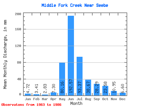
| Statistic | Jan | Feb | Mar | Apr | May | Jun | Jul | Aug | Sep | Oct | Nov | Dec | Annual |
|---|---|---|---|---|---|---|---|---|---|---|---|---|---|
| Mean | 4.59 | 3.19 | 3.01 | 7.21 | 80.03 | 192.38 | 93.55 | 38.74 | 28.60 | 23.10 | 10.76 | 6.72 | 488.12 |
| Standard Deviation | 1.25 | 0.91 | 0.97 | 4.37 | 32.41 | 58.27 | 37.00 | 16.59 | 17.47 | 14.96 | 4.38 | 2.07 | 97.24 |
| Min | 2.83 | 1.72 | 1.89 | 2.74 | 30.18 | 83.05 | 30.18 | 17.92 | 10.95 | 8.49 | 5.48 | 3.77 | 320.42 |
| Max | 7.54 | 5.16 | 5.66 | 18.25 | 139.56 | 316.70 | 165.02 | 71.67 | 81.23 | 70.72 | 22.82 | 11.31 | 689.91 |
| Coefficient of Variation | 0.27 | 0.28 | 0.32 | 0.60 | 0.41 | 0.30 | 0.40 | 0.43 | 0.61 | 0.65 | 0.41 | 0.31 | 0.20 |
 Return to R-Arctic Net Home Page