|
|
|||||||||||||||||
| Point ID: 265 | Downloads | Plots | Site Data | Code: 05BF016 |
|
|
|||||||||||||||||
| Download | |
|---|---|
| Site Descriptor Information | Site Time Series Data |
| Link to all available data | |
| View: | Time Series | All |
| Units: | m3/s |
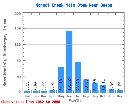
| Statistic | Jan | Feb | Mar | Apr | May | Jun | Jul | Aug | Sep | Oct | Nov | Dec | Annual |
|---|---|---|---|---|---|---|---|---|---|---|---|---|---|
| Mean | 5.17 | 4.01 | 4.12 | 7.67 | 64.05 | 153.10 | 76.74 | 32.96 | 24.41 | 18.98 | 9.96 | 6.90 | 413.23 |
| Standard Deviation | 1.20 | 0.74 | 0.77 | 3.15 | 28.70 | 56.43 | 33.06 | 13.90 | 14.24 | 10.37 | 4.34 | 2.05 | 87.87 |
| Min | 2.57 | 2.86 | 2.85 | 3.31 | 26.24 | 61.00 | 26.24 | 15.69 | 9.66 | 7.70 | 4.97 | 3.99 | 261.88 |
| Max | 7.99 | 5.72 | 6.27 | 16.01 | 139.18 | 265.00 | 151.15 | 78.71 | 65.97 | 58.18 | 25.12 | 12.26 | 559.05 |
| Coefficient of Variation | 0.23 | 0.18 | 0.19 | 0.41 | 0.45 | 0.37 | 0.43 | 0.42 | 0.58 | 0.55 | 0.44 | 0.30 | 0.21 |
 Return to R-Arctic Net Home Page