|
|
|||||||||||||||||
| Point ID: 247 | Downloads | Plots | Site Data | Code: 05BD005 |
|
|
|||||||||||||||||
| Download | |
|---|---|
| Site Descriptor Information | Site Time Series Data |
| Link to all available data | |
| View: | Time Series | All |
| Units: | m3/s |
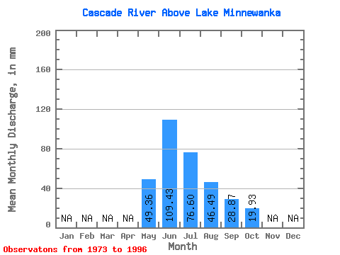
| Statistic | Jan | Feb | Mar | Apr | May | Jun | Jul | Aug | Sep | Oct | Nov | Dec | Annual |
|---|---|---|---|---|---|---|---|---|---|---|---|---|---|
| Mean | 49.35 | 109.44 | 76.59 | 46.49 | 28.87 | 19.92 | |||||||
| Standard Deviation | 19.97 | 38.69 | 26.98 | 13.85 | 6.52 | 2.72 | |||||||
| Min | 21.23 | 62.23 | 41.00 | 29.67 | 20.15 | 14.57 | |||||||
| Max | 94.97 | 191.26 | 141.57 | 75.50 | 46.59 | 25.48 | |||||||
| Coefficient of Variation | 0.41 | 0.35 | 0.35 | 0.30 | 0.23 | 0.14 |
 Return to R-Arctic Net Home Page