|
|
|||||||||||||||||
| Point ID: 238 | Downloads | Plots | Site Data | Code: 05BC001 |
|
|
|||||||||||||||||
| Download | |
|---|---|
| Site Descriptor Information | Site Time Series Data |
| Link to all available data | |
| View: | Time Series | All |
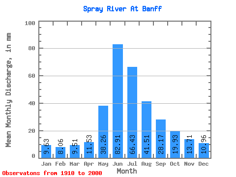
| Units: | m3/s |
| Statistic | Jan | Feb | Mar | Apr | May | Jun | Jul | Aug | Sep | Oct | Nov | Dec | Annual |
|---|---|---|---|---|---|---|---|---|---|---|---|---|---|
| Mean | 9.62 | 8.13 | 9.51 | 11.53 | 38.25 | 82.91 | 66.42 | 41.51 | 28.17 | 19.92 | 13.71 | 10.95 | 338.85 |
| Standard Deviation | 5.62 | 5.41 | 9.72 | 11.88 | 31.99 | 70.49 | 56.17 | 28.18 | 18.98 | 14.17 | 8.91 | 6.65 | 239.13 |
| Min | 2.33 | 1.42 | 1.76 | 3.00 | 6.44 | 15.37 | 11.30 | 8.19 | 6.58 | 4.65 | 3.67 | 2.69 | 85.57 |
| Max | 21.95 | 39.09 | 89.03 | 101.74 | 128.36 | 247.43 | 237.41 | 115.13 | 85.82 | 56.85 | 33.81 | 24.10 | 846.16 |
| Coefficient of Variation | 0.58 | 0.67 | 1.02 | 1.03 | 0.84 | 0.85 | 0.85 | 0.68 | 0.67 | 0.71 | 0.65 | 0.61 | 0.71 |
 Return to R-Arctic Net Home Page