|
|
|||||||||||||||||
| Point ID: 225 | Downloads | Plots | Site Data | Code: 05BA003 |
|
|
|||||||||||||||||
| Download | |
|---|---|
| Site Descriptor Information | Site Time Series Data |
| Link to all available data | |
| View: | Time Series | All |
| Units: | m3/s |
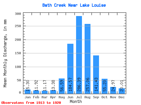
| Statistic | Jan | Feb | Mar | Apr | May | Jun | Jul | Aug | Sep | Oct | Nov | Dec | Annual |
|---|---|---|---|---|---|---|---|---|---|---|---|---|---|
| Mean | 15.30 | 12.03 | 11.17 | 13.37 | 56.59 | 184.59 | 286.35 | 257.03 | 141.44 | 55.19 | 24.97 | 20.01 | 1170.19 |
| Standard Deviation | 2.14 | 1.89 | 1.36 | 3.35 | 19.76 | 83.07 | 60.57 | 62.51 | 50.76 | 19.27 | 3.56 | 3.67 | 223.11 |
| Min | 12.04 | 9.64 | 9.75 | 9.89 | 36.57 | 113.51 | 186.22 | 169.97 | 97.41 | 39.54 | 21.63 | 14.42 | 1010.99 |
| Max | 17.75 | 14.73 | 12.76 | 16.64 | 81.62 | 343.99 | 368.48 | 362.93 | 237.76 | 90.73 | 30.56 | 24.09 | 1425.20 |
| Coefficient of Variation | 0.14 | 0.16 | 0.12 | 0.25 | 0.35 | 0.45 | 0.21 | 0.24 | 0.36 | 0.35 | 0.14 | 0.18 | 0.19 |
 Return to R-Arctic Net Home Page