|
|
|||||||||||||||||
| Point ID: 224 | Downloads | Plots | Site Data | Code: 05BA002 |
|
|
|||||||||||||||||
| Download | |
|---|---|
| Site Descriptor Information | Site Time Series Data |
| Link to all available data | |
| View: | Time Series | All |
| Units: | m3/s |
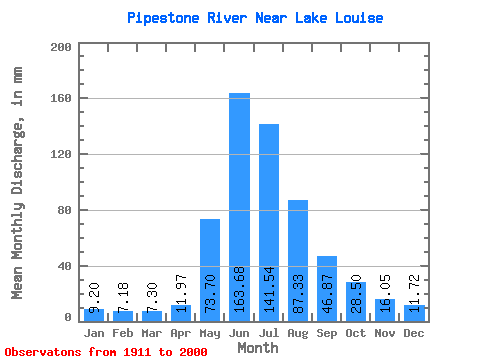
| Statistic | Jan | Feb | Mar | Apr | May | Jun | Jul | Aug | Sep | Oct | Nov | Dec | Annual |
|---|---|---|---|---|---|---|---|---|---|---|---|---|---|
| Mean | 9.20 | 7.24 | 7.30 | 11.97 | 73.69 | 163.68 | 141.52 | 87.31 | 46.87 | 28.50 | 16.05 | 11.72 | 607.73 |
| Standard Deviation | 1.93 | 1.47 | 1.78 | 4.91 | 29.29 | 43.32 | 42.80 | 22.60 | 12.18 | 6.02 | 5.59 | 3.72 | 73.69 |
| Min | 5.79 | 4.67 | 3.45 | 4.90 | 29.76 | 97.41 | 81.56 | 53.38 | 31.09 | 17.68 | 9.32 | 7.68 | 486.51 |
| Max | 13.48 | 10.29 | 10.59 | 22.62 | 165.41 | 279.53 | 257.30 | 136.53 | 87.25 | 46.65 | 34.73 | 23.89 | 734.06 |
| Coefficient of Variation | 0.21 | 0.20 | 0.24 | 0.41 | 0.40 | 0.27 | 0.30 | 0.26 | 0.26 | 0.21 | 0.35 | 0.32 | 0.12 |
 Return to R-Arctic Net Home Page