|
|
|||||||||||||||||
| Point ID: 222 | Downloads | Plots | Site Data | Code: 05AK001 |
|
|
|||||||||||||||||
| Download | |
|---|---|
| Site Descriptor Information | Site Time Series Data |
| Link to all available data | |
| View: | Time Series | All |
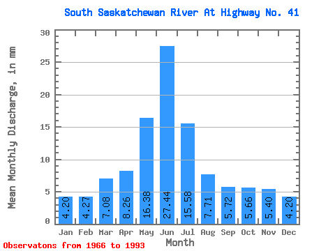
| Units: | m3/s |
| Statistic | Jan | Feb | Mar | Apr | May | Jun | Jul | Aug | Sep | Oct | Nov | Dec | Annual |
|---|---|---|---|---|---|---|---|---|---|---|---|---|---|
| Mean | 2.97 | 3.05 | 5.01 | 5.85 | 11.59 | 19.42 | 11.02 | 5.46 | 4.04 | 4.00 | 3.82 | 2.97 | 78.47 |
| Standard Deviation | 0.82 | 0.77 | 1.82 | 2.60 | 6.64 | 11.27 | 7.43 | 3.71 | 2.72 | 2.18 | 1.16 | 0.92 | 29.95 |
| Min | 1.72 | 2.00 | 2.68 | 1.43 | 1.55 | 3.57 | 1.53 | 1.64 | 1.30 | 1.32 | 1.96 | 1.57 | 32.08 |
| Max | 4.83 | 4.66 | 9.86 | 13.27 | 25.48 | 48.70 | 28.48 | 16.96 | 14.18 | 10.31 | 6.83 | 5.40 | 134.17 |
| Coefficient of Variation | 0.28 | 0.25 | 0.36 | 0.44 | 0.57 | 0.58 | 0.68 | 0.68 | 0.67 | 0.55 | 0.30 | 0.31 | 0.38 |
 Return to R-Arctic Net Home Page