|
|
|||||||||||||||||
| Point ID: 211 | Downloads | Plots | Site Data | Code: 05AH042 |
|
|
|||||||||||||||||
| Download | |
|---|---|
| Site Descriptor Information | Site Time Series Data |
| Link to all available data | |
| View: | Time Series | All |
| Units: | m3/s |
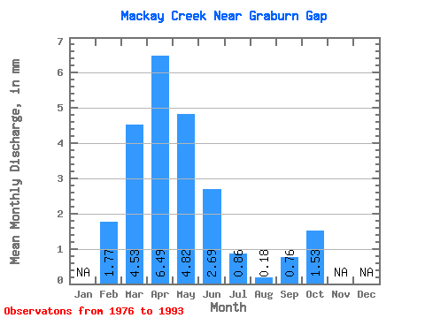
| Statistic | Jan | Feb | Mar | Apr | May | Jun | Jul | Aug | Sep | Oct | Nov | Dec | Annual |
|---|---|---|---|---|---|---|---|---|---|---|---|---|---|
| Mean | 1.77 | 4.54 | 6.50 | 4.80 | 2.69 | 0.85 | 0.19 | 0.75 | 1.54 | ||||
| Standard Deviation | 2.10 | 4.46 | 6.83 | 6.06 | 6.94 | 2.31 | 0.69 | 2.06 | 2.00 | ||||
| Min | 0.00 | 0.39 | 0.28 | 0.04 | 0.00 | 0.00 | 0.00 | 0.00 | 0.00 | ||||
| Max | 6.21 | 17.87 | 22.95 | 18.55 | 29.65 | 9.81 | 2.92 | 6.42 | 6.28 | ||||
| Coefficient of Variation | 1.18 | 0.98 | 1.05 | 1.26 | 2.58 | 2.73 | 3.66 | 2.76 | 1.30 |
 Return to R-Arctic Net Home Page