|
|
|||||||||||||||||
| Point ID: 205 | Downloads | Plots | Site Data | Code: 05AH036 |
|
|
|||||||||||||||||
| Download | |
|---|---|
| Site Descriptor Information | Site Time Series Data |
| Link to all available data | |
| View: | Time Series | All |
| Units: | m3/s |
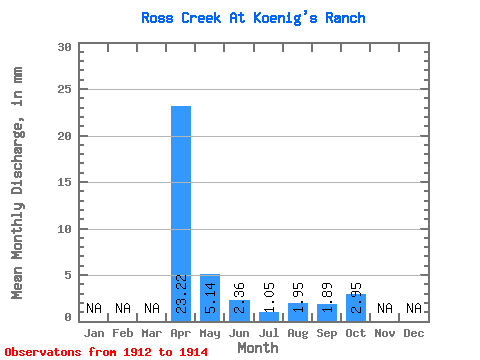
| Statistic | Jan | Feb | Mar | Apr | May | Jun | Jul | Aug | Sep | Oct | Nov | Dec | Annual |
|---|---|---|---|---|---|---|---|---|---|---|---|---|---|
| Mean | 23.20 | 5.14 | 2.35 | 1.05 | 1.95 | 1.89 | 2.95 | ||||||
| Standard Deviation | 21.50 | 1.19 | 0.89 | 2.43 | 2.05 | 0.83 | |||||||
| Min | 8.00 | 5.14 | 1.60 | 0.03 | 0.18 | 0.55 | 1.98 | ||||||
| Max | 38.40 | 5.14 | 3.72 | 1.68 | 4.72 | 4.25 | 3.49 | ||||||
| Coefficient of Variation | 0.93 | 0.51 | 0.85 | 1.24 | 1.08 | 0.28 |
 Return to R-Arctic Net Home Page